File:Map Gallia Tribes Towns.png
From WikiMD's WELLNESSPEDIA

Size of this preview: 590 × 599 pixels. Other resolutions: 236 × 240 pixels | 473 × 480 pixels | 787 × 799 pixels.
Original file (787 × 799 pixels, file size: 352 KB, MIME type: image/png)
Summary
| Description |
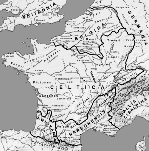
Afrikaans: Romeinse provinsies en stamgroepe van die Galliese gebied in die laat 1ste eeu v.C.
Ελληνικά: Χάρτης της Γαλατίας και των κελτικών φυλών τον 1ο αιώνα π.Χ.
Français : Provinces romaines et les peuples proto-basques, celtes et germanique à la fin du Ier siècle av. J-C.
English: Roman provinces and the proto-Basque, Celtic and Germanic peoples at the end of the 1st century BC. J-C. |
| Date | |
| Source | Own work |
| Author | User:Feitscherg |
| Other versions |
Derivative works of this file: |

|
This historical map image could be re-created using vector graphics as an SVG file. This has several advantages; see Commons:Media for cleanup for more information. If an SVG form of this image is available, please upload it and afterwards replace this template with
{{vector version available|new image name}}.It is recommended to name the SVG file “Map Gallia Tribes Towns.svg”—then the template Vector version available (or Vva) does not need the new image name parameter. |
Licensing
I, the copyright holder of this work, hereby publish it under the following license:

|
Permission is granted to copy, distribute and/or modify this document under the terms of the GNU Free Documentation License, Version 1.2 or any later version published by the Free Software Foundation; with no Invariant Sections, no Front-Cover Texts, and no Back-Cover Texts. A copy of the license is included in the section entitled GNU Free Documentation License. |
| This file is licensed under the Creative Commons Attribution-Share Alike 3.0 Unported license. | ||
| ||
| This licensing tag was added to this file as part of the GFDL licensing update. |
File history
Click on a date/time to view the file as it appeared at that time.
| Date/Time | Thumbnail | Dimensions | User | Comment | |
|---|---|---|---|---|---|
| current | 19:43, 23 May 2014 | | 787 × 799 (352 KB) | wikimediacommons>Zorion | Two aquitanian tribes added. Volcates replaced by Vasates |
File usage
The following page uses this file:
