File:Wright–Molyneux Map.png
From WikiMD's WELLNESSPEDIA
Size of this preview: 800 × 575 pixels. Other resolutions: 2,560 × 1,839 pixels | 4,000 × 2,874 pixels.
Original file (4,000 × 2,874 pixels, file size: 20.04 MB, MIME type: image/png)
Summary[edit]
| Summary | |
|---|---|
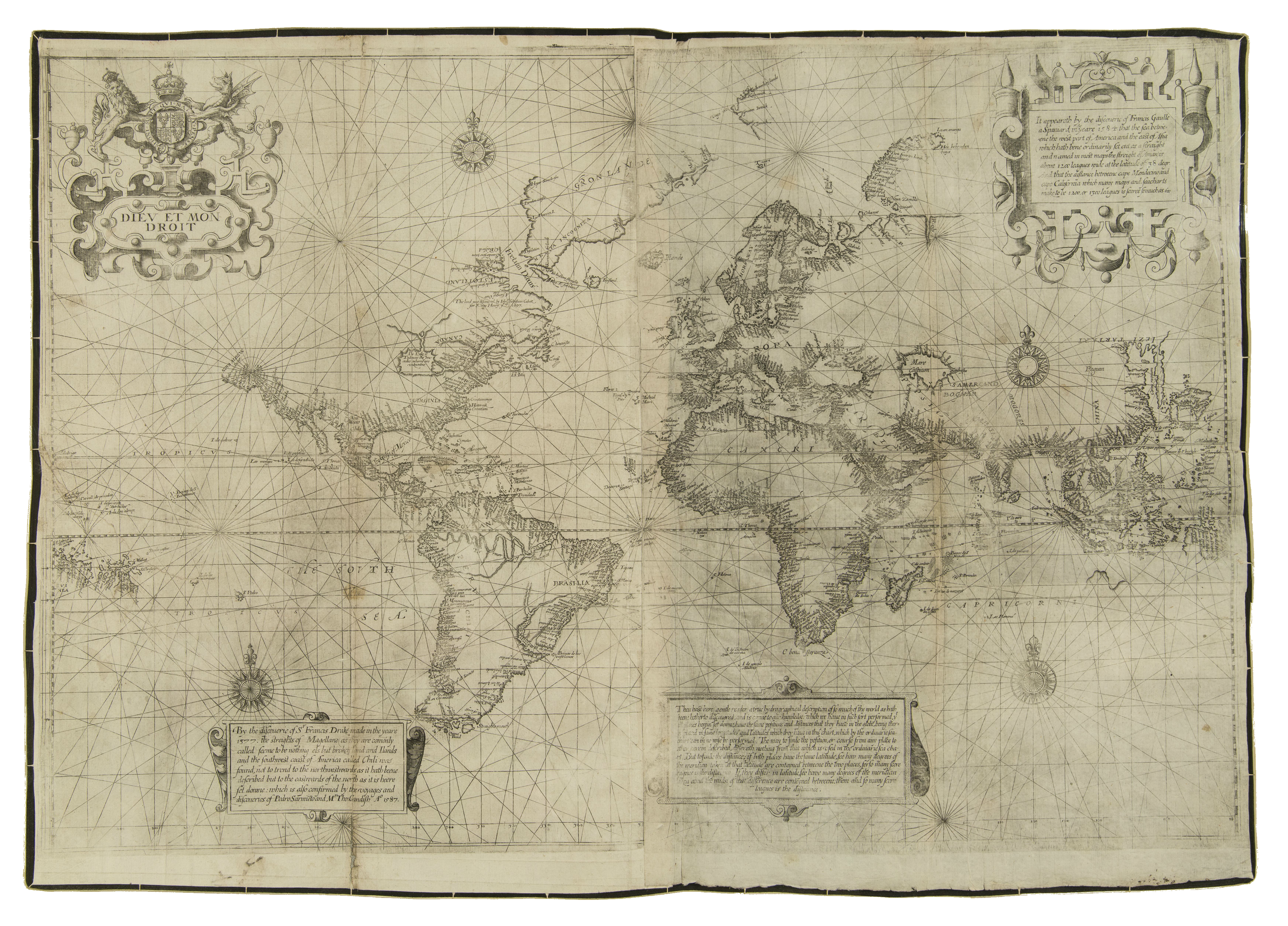
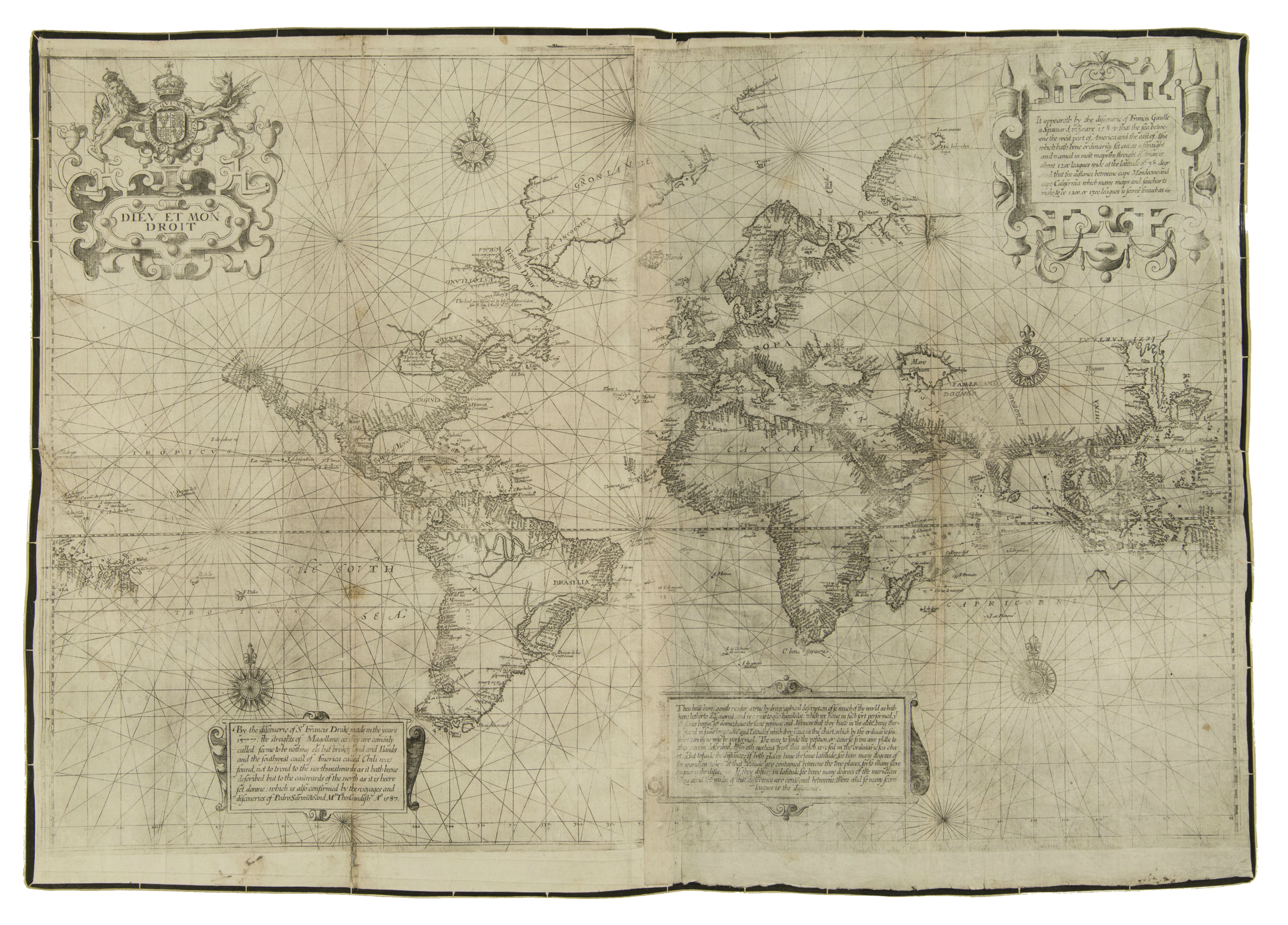
| Description | Caption: Thou hast here gentle reader a true hydrographical description of so much of the world as hath beene hetherto discouered, and is comme to our knowledge. which we haue in such sort performed, yt all places herein set downe, haue the same positions and distances that they haue in the globe, being therin placed in same longitudes and latitudes which they haue in this chart, which by the ordinarie sea-chart can in no wise be performed. The way to find the position, or course from any place to other herein described, differeth nothing from that which is vsed in the ordinarie sea chart. But to finde the distance; if both places haue the same latitude, see how many degrees of the meridian taken at that latitude are contayned betweene the two places, for so many score leagues is the distance. If they differ in latitude, see howe many degrees of the meridian taken about the midst of that difference are conteyned betweene; them and so many score leagues is the distaunce.Elsewhere: "I haue contented my self with inserting into the worke one of the best generall mappes of the world onely, untill the comming out of a very large and most exact terrestrial Globe, collected and reformed according to the newest, secretest, and latest discoveries, both Spanish, Portugall, and English, composed by M. Emmerie Mollineux of Lambeth, a rare Gentleman in his profession, being therein for divers yeeres, greatly supported by the purse and liberalitie of the worshipfull marchant M. William Sanderson."A map of the world by the mathematical adaptation of the Mercator Projection computed by Edward Wright and used to flatten the information on the c. 1592 globe made by Emery Molyneux and thus generally known as the Wright–Molyneux Map. Possibly charted in 1599, published in 1600 as an addendum to Vol. I of the 2nd edition of Richard Hakluyt's Principall Nauigations... |
| Source | Wikimedia Commons file page |
| Author | Edward Wright, after the c. 1592 globe of Emery Molyneux |
| Permission | See original Commons license details. |
Licensing[edit]
Public Domain
This file is in the public domain and may be used without restriction.
Please see the linked source page for the original file history, attribution information, and licensing details.
Original attribution and file history: Wikimedia Commons
File history
Click on a date/time to view the file as it appeared at that time.
| Date/Time | Thumbnail | Dimensions | User | Comment | |
|---|---|---|---|---|---|
| current | 22:29, 8 June 2026 | | 4,000 × 2,874 (20.04 MB) | Maintenance script (talk | contribs) | == Summary == Importing file |
You cannot overwrite this file.
File usage
The following page uses this file:
